GPS based Wildlife animal tracking system is used to track the location of Animals in wildlife reserves or national parks. This project utilizes a GPS modem and a GSM modem for this purpose. A forest officer or Government authority person will get these SMS containing Longitude and Latitude.
As the human race or human society is growing, wildlife animals or wild animals are in danger. But as per nature’s rule, every living creature on this earth is important and has an important role ecosystem. Also, we get some medicines or useful drugs from some animals. We have already realized this, so in every country, we see that there are wildlife animal reserves and national parks where these animals can live freely in forests or in a jungle however these are monitored by human beings.
Also nowadays these wildlife national parks have become popular tourist places. Many endangered species or rare species are available or preserved here. For example white tigers, pandas, and many other animals. But these animals also undergo some diseases or there can be some situations where human being attention is required for these animals like vaccination of these animals. If they met with some accident or are hurt then we have to cure their wounds, in such cases, we need to catch those animals and do the required treatments.
The main problem in such situations is that in large wildlife sanctuaries these animals are really hard to locate. Due to this many times, we have to search the entire area.
To avoid such problems we are implementing a project called “Wildlife animal tracking using GPS and GSM technology”. In this project, a GPS modem helps to get the coordinates of the location. This modem can require a minimum of 3 satellites Global Positioning System modem receives location parameters like Longitude and Latitude from the satellite.
We have also used a GSM modem which sends these parameters to a particular mobile number through SMS. This mobile number can be of a Forest officer or any concerned Government authority person. This SMS will help to track the exact location of the animal. And if the animal moves inside the animal reserves or forest then the particular variable location parameters are received.
We can also add a temperature sensor to this project. If the animal has a fever or if there are some wounds on the animal’s body and because of the wounds temperature of the animal rises, then we can send an SMS to the forest officer so he can give immediate attention. This SMS will contain messages like “Temperature crosses threshold level” and this message will also contain GPS coordinates. This project should be attached to the animal body. So as the animal moves from one place to another, the GPS coordinate will change and this change will be intimated using SMS. We can get periodically SMS to the officer’s mobile number
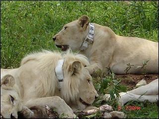
Talking about existing technologies in some countries, many animals have belts on their neck. This belt has a wireless transmitter. A wildlife officer has a receiver in his/her hand and will search the location. However the main drawback of this technique is that range of wireless transmitters is less. In some sensors, it is 100 meters in some sensors it is in few kilometers but not more than that. But as we know that forests and wildlife national parks are hundreds of kilometers in length. And in such situations, these wireless transmitters are not much useful and they are time-consuming. With the help of GPS technology and GSM technology, we can track an animal in a forest of thousands of kilometers in length.
Contents of Text SMS are as below:
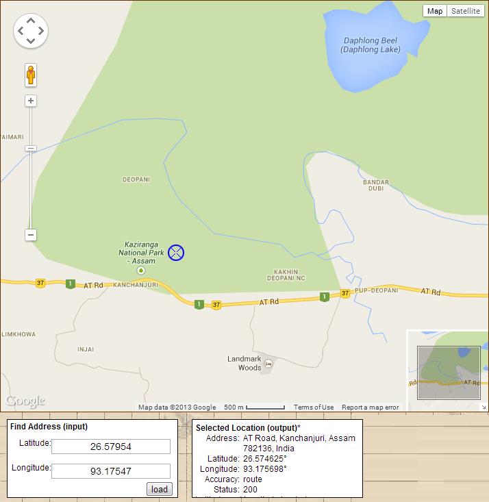
Coordinates of Animal:-
Longitude = 26.57954
Latitude = 93.17547
You will get the following documents with this project:
Once the user has received the location parameter in the format of text SMS, then he can use this location on the map to find the exact geographical location. Finding out the location on a printed map is quite difficult and it will consume lots of time. However, nowadays many website providers have online maps. Google map is one of the most used and famous online map provider services. Users can read the text SMS and then they can type these parameters in Google Maps to find the exact location.
This project has one limitation: – In actual use this project will be operated on a rechargeable battery. So this battery needs to be recharged. For the longer operation of the battery, we need to use low-power consumption devices, ICs, and components; this will increase the cost of the system.
YouTube video coming soon. The video for this project is not available right now, we are planning to upload a video soon. Meanwhile, you can watch a video of another project in the category of GPS-based projects.
View Comments
sir we want tract the domestic animals inthe migratory system of rearing.Is it is possible.What type of output results we can get?
I would like to if you can do a special tracking for cattle im in country whr=ere there is stock theft. The device will be preferred in tags not belts.
What's the smallest tag available. weight? dimensions?
VEHICLE TRACKING SYSTEM WAS VERY GOOD BY THE HELP OF THIS WE CAN TRACK ALL THE BIKE AND CAR ,MOTAR
range of apparatus required
i just want to ask what will attached to wildlife so that can interconect with gsm and GPS TRACKING
i want to ask in which currency is that project price?
Hw can we attach this project to all the animals in forests??